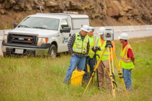
Smart Services, Inc. provides a wide range of surveying services meeting the needs of our public and private clients. Our firm was built on the performance of Mortgage, ALTA, and Boundary surveys where we established a solid reputation for quality and accurate work. Since our start we have expanded our services to include Horizontal and Vertical Control Surveys, Basemaps & GIS, Right-of-Way Plans, Topographic Surveys, GNSS Surveys, Terrestrial based LiDAR, Route Surveys, Cadastral Surveys, ALTA/NSPS Land Title Surveys, Hydrographic Surveys, As-Built Surveys, FEMA Flood Mapping & Elevation Certificates, and Construction Staking.


 We employ survey crews equipped with Robotic Total Stations, Terrestrial Scanners, ODOT VRS and RTK GNSS systems, static GNSS systems, and optical levels. We have the CADD and GIS expertise to prepare high quality basemaps, right-of-way plans per ODOT Design Manual Guidelines and Specifications, and GIS mapping tailored to our client’s needs.

Topographic Surveys

Topographic Surveys provide horizontal and vertical locations for a project. Various services can be covered within a project survey, including utility location, bathymetric data, outfall and invert elevations, and establishment of permanent control markers. Our ground survey data can also be supplemented with LiDAR. Our finished product can be provided electronically with all linework showing the surveyed surface features, utilities, and contours within a project area. We have completed surveys for lake volume calculations, site development, trail improvements, water and sewer lines, and roadway projects.

Route Surveys and Project Survey Control

Roadways, highways, and water and sewer line projects often require a Route Survey for planning of the right-of-way. The field survey provides for the location of right-of-way lines and centerline in relation to property lines and other features. Survey controls are established to set a base for consistent and accurate horizontal and vertical control.

As-Built Surveys

As-built surveys can field locate items such as structure locations, invert elevations, pipe material, finished floor elevation and pipe grades. Once data is collected in the field we analyze and compare the data to the construction plans. Record mylars can be produced, illustrating items not within acceptable construction tolerances.

Construction Staking

Smart surveyors use construction plans to stake reference points for the construction of buildings, roads, or other improvements. We perform all calculations necessary for the field crew to accurately stake the project as designed. Site grade staking can also be performed on a grid pattern.

GPS & GIS

Trying to meet the Municipal Separate Storm Sewer System (MS4) regulations? Smart Services uses survey-grade GPS receivers and handheld data collectors for use in our collection of GIS data. Data collected in the field is then mapped using AutoCAD and/or GIS software to meet the specific needs of our client.

ALTA/ACSM Land Title Surveys

The American Land Title Association/American Congress of Surveying and Mapping (ALTA/ACSM) standardized a survey format that would be acceptable to all title companies for conveyances and for pre- and post-development sites. We have provided field measurements and preparation of more than 100 plats for commercial loan transactions.

Boundary & Line Staking Surveys

Want to make sure you are building your fence on your property? We provide boundary surveys including field measurement, courthouse research, legal description, and preparation of a plat for determining boundary lines. The “Standards for Boundary Surveys” as defined in Chapter 4733-37 of the OAC. To make the process go smoothly we can take the legal description to the county engineer’s office for pre-approval. Line staking surveys can also be provided, setting iron pins, concrete markers, or other permanent or temporary markers indicating the property boundary.

Mortgage Location Surveys

Lenders often require that potential parcel problems, such as encroachments, are identified prior to closing a loan. The “Standards for Mortgage Location Surveys” as defined in Chapter 4733-38 of the Ohio Administrative Code (OAC) are followed. Our surveyors have been providing mortgage location surveys for over 25 years.

FEMA Flood Mapping & Elevation Certificates

Are you concerned your building is in a floodplain? A Flood Elevation Certificate provides data to help properly rate properties for flood insurance and is used by the Federal Emergency Management Agency (FEMA). An Elevation Certificate can determine where a structure is located in relationship to the base flood elevation. Flood mapping surveys can be performed to allow detailed calculations for determining flood impacts on development sites and other areas being improved. We can also submit on-line elevation certificate forms directly to FEMA.

Our Services

SURVEYING & RIGHT-OF-WAY

Smart Services provides a wide range of surveying services meeting the needs of our public and private clients. Our firm was built on the performance of Mortgage, ALTA, and Boundary surveys where we established a solid reputation for quality and accurate work. Since our start we have expanded our services to include Topographic Surveys, FEMA Flood Mapping and Elevation Certificates, Bathymetric Surveys, Project Survey Control, Construction Staking, Final Site Staking, Site Engineering Surveys, Route Surveys, and As-Built Surveys.

We employ survey crews equipped with Robotic Total Stations, ODOT VRS and RTK GPS systems, static GPS systems, and optical levels. We have the CADD and GIS expertise to prepare high quality basemaps, right-of-way plans per ODOT Design Manual Guidelines and Specifications, and GIS mapping tailored to our client’s needs.

Our Traffic Engineer conducting a traffic study

TRAFFIC ENGINEERING

As part of Smart Services, TES has the resources to perform a full range of traffic engineering, traffic counts, and transportation planning services. We have certified Professional Traffic Operations Engineers and in-house traffic counting equipment. The services we provide our clients range from basic signal operations and traffic counts to more detailed traffic design and traffic studies, all the way through detailed Transportation Planning studies. We address a wide range of transportation facilities and issues, including maintenance of traffic, school and pedestrian crossings, traffic calming, striping, and signal interconnect.
Wetland delineation Environmental services

ENVIRONMENTAL SERVICES

Smart Services, Inc. provides a vast array of environmental consulting services to assist our clients through state and federal regulatory processes. We can provide basic environmental reviews in the form of Environmental Site Assessment (ESA) Screenings and Phase I ESAs, to more intensive Phase II ESAs, underground storage tank (UST) removals, and Asbestos-Containing Material (ACM) Surveys. When a site is planned for development, we can assist with the permitting related to impacts to wetlands, streams, threatened and endangered species, and cultural resources. We can complete Nationwide and Individual Section 401/404 permits, Individual Ohio Section 401 Water Quality Certifications, and Isolated Wetland Permits. We also provide a wide range of environmental services on state and local transportation projects, providing environmental documentation and regulatory agency coordination.